 This site uses cookies in order to function as expected. By continuing, you are agreeing to our
 Overview of the Country
Background of the Country and its biodiversity:
Located at the easternmost corner of the Mediterranean and at the crossroads between Europe, Asia and Africa, Lebanon is influenced by the Mediterranean and provided as such by a variable wealth of habitats with its islands, coastal lands, rivers and high mountains. Four principal factors have interacted in this region to produce an exceptionally rich and unique biodiversity: biogeography, geology, ecology and historic human settlements in the Mediterranean area (Blondel and Aronson 1999). More than any other region in the world, the Mediterranean region best exemplifies the environmental change in response to man environment interactions. Lebanon is an integral region in the Mediterranean Basin, it falls within a recognized center of plant diversity and is considered a global hotspot (Myers et al. 2000).
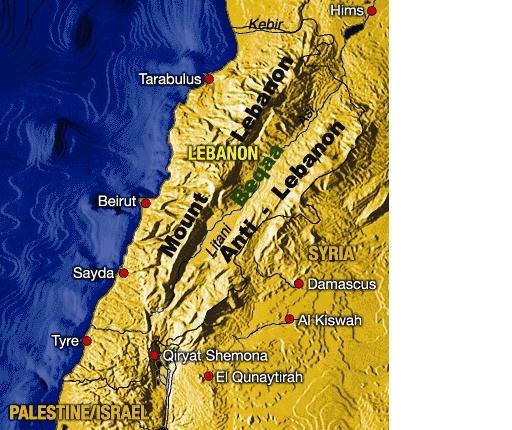
Lebanon has a total surface area of only 10,425 km2, it is highly mountainous with a mosaic of biotopes and natural environments, dominated by a typical Mediterranean climate (Blondel and Aronson 1999). The topography of the country imposes various micro-environments for both terrestrial and fresh water biodiversity, most ecosystems, however, have narrow ranges and their biotypes are struggling for existence against a changing environment. There are five geomorphological regions in Lebanon (CDR/ECODIT-IAURIF, 1997):
1. Coastal zone, 250 km long, included the shoreline and continental shelf, the coastal plains and the foothills of Mount Lebanon up to elevations of 250 meters.
2. Mount Lebanon range, about 160 km long and 25-40 km wide, includes middle and high elevation zones above 250 meters. It rises from Akkar in the North and extends South to the hills of Jabal Amel. Mount Lebanon peaks at 3,088 meters at Kornet es-Saouda in the north.
3. Beqaa plain, a land depression separating the Mount Lebanon and Anti- Lebanon ranges. It comprises an 8-12 km wide fertile corridor and is about 120 km from North to South. The Beqaa plain is drained by the Aassi River from the North and by the Litani River from the South
4. Anti-Lebanon range, extends across the Lebanese-Syrian borders. It peaks at 2,600 meters (Tallat Moussa). Slopes are generally more gentle compared to Mount Lebanon. The southern sections of he Anti-Lebanon range include Jabal el Cheikh (Mount Hermon), which intercepts rainwater and redistributes water into at least three main watersheds across Lebanon, Syria and Palestine.
5. South Lebanon, an elevated plateau that extends a short distance inland from the western shores of South Lebanon to the Mount Hermon foothills in the East. This region is intersected by many seasonal streams flowing from west to east and discharging into the Mediterranean Sea.
Geologically, Lebanon consists almost exclusively of limestones. Most are of Cretaceous origin, with Jurassic limestones in some areas, principally in the south. Only in a few places, especially in the north at Akkar, do basaltic rocks appear. Briefly, the topography consists of a narrow coastal plain and two imposing mountain ranges (Lebanon and Anti-Lebanon) separated by the Beqaa Valley (at 800–1000 metres), which is a part of the African Rift complex and which is composed of eroded material from the mountains. The Lebanon range mostly rises from the sea and gradually decreases in altitude to the south. The southernmost point of the Anti-Lebanon is the highest part of the range on the Hermon. Further north, the Anti-Lebanon Mountains gradually decrease in altitude.
The climate is subject to considerable variation according to altitude and locality. Generally it can be described as Mediterranean, with a few particularities. Predominantly westerly winds bring abundant rain—principally in winter—while the summers are mainly dry. Coastal areas receive over 800 mm of rain p.a., and most montane areas over 1000 mm. Most rain falls on the western slopes of the Lebanon range, with the summits receiving less than lower areas. The Beqaa valley and Anti-Lebanon generally receive less than 700 mm and the Hermel semi-desert in the northern Beqaa less than 250 mm.
In coastal areas, the mean temperature during the year is 20 °C while above 1800 meters it is around 10 °C. Most high mountains in both ranges are snow-covered until July or August and on the peaks, isolated pockets of permanent snow occur in shaded places. The climate is subject to considerable variation according to altitude and locality. Generally it can be described as Mediterranean, with a few particularities. Predominantly westerly winds bring abundant rain—principally in winter—while the summers are mainly dry. Coastal areas receive over 800 mm of rain p.a., and most montane areas over 1000 mm. Most rain falls on the western slopes of the Lebanon range, with the summits receiving less than lower areas. The Beqaa valley and Anti-Lebanon generally receive less than 700 mm and the Hermel semi-desert in the northern Beqaa less than 250 mm.
5. Biodiversity (Biomes, ecological regions, flora, endemism, threats)
The Mediterranean region which belongs to the Mediterranean biome is one of 25 hotspots of biodiversity in the world and ranks third in the world among hotspots in both plant diversity and endemism, surpassed only by the ultra-diverse Tropical Andes and Sundaland. Of the 25,000 species of vascular plants in this hotspot, 13,000 (52 percent) are found nowhere else in the world. Many of the endemic species are not evenly distributed over the Mediterranean region but concentrated on islands, peninsulas, cliffs, and peaks. It encompasses the Mediterranean vegetation that is the mirror of the five Mediterranean climates. The Mediterranean hotspot is characterized by ten "mini-hotspots" within the larger area, where unusual amounts of original vegetation and endemic species still survive. These mini-hotspots cover about 15 percent of total land area but account for 37 percent of the region's endemic species, establishing their status as conservation priorities in the Mediterranean Basin.
The important components of Mediterranean vegetation (Arbutus, Calluna, Ceratonia, Chamaerops, and Larus) are relicts from the ancient forests that dominated the Basin 2 million years ago. Additionally, cold shrubs (Artemisia, Astralagus, and Ephedra) and trees (Acer, Betula, Cercis, Fagus, and Ulmus) invaded during the Pleistocene from Europe and Asia and are still present in the Basin's flora. Notable plant species in the hotspot include the cedars (Cedrus spp.). One species is endemic to Cyprus and represented by a tiny remaining population; another is abundant in Morocco and Algeria but threatened by the timber trade; and a third, the famous Lebanon cedar (C. libani), has been exploited since the rise of civilization in the Fertile Crescent. The only palm native to the Mediterranean, Phoenix theophrasti, is found in a tiny part of Crete and on Turkey's Datca Peninsula, two areas of the Mediterranean Basin experiencing substantial tourism development.
The vegetation of Lebanon which is mostly part of the Mediterranean is dominated by hard-leafed or sclerophyllus shrublands called maquis or matorral and includes representatives from the genera Juniperus, Myrtus, Olea, Pistacia, and Quercus. This vegetation is similar in appearance to the chaparral vegetation of California and the matorral of Central Chile. Unfortunately, the maquis in many Lebanese areas is degraded into guarrigue and batha.
In fact, the Lebanese natural landscape is rich, offering 9,119 species of which 4,633 are plants and 4,486 animals (NBSAP 1998). Floristic richness is estimated to include 2,600 vascular plant species of which c.400 are endemic to Lebanon, Syria and Palestine (15%) and c.92 are endemic to Lebanon (3. 5%) (BCSR).
There are five general geomorphological regions in Lebanon: (i) The Coastal Zone including the shoreline (220 km), the coastal plain and the western chain foothills; (ii) the middle and high elevation zones of Mount Lebanon; (iii) the Beqaa Plain; (iv) Anti Lebanon; and (v) South Lebanon.
On the western slopes of the Lebanon range, the main phyto-geographical zones are easy to define. They range from the lower Mediterranean zone (0–500 meters) to the alpine zone (above 2500 meters) successively through the middle Mediterranean zone (500–1000 meters), upper Mediterranean zone (1000–1500 meters), cedar zone (1500–2000 meters) and sub-alpine zone (2000–2500 meters). On the east slope of the Lebanon, the Beqaa valley and the Anti-Lebanon there is a gradual change to continental Mediterranean and sub-desert conditions. Most will not be readily apparent to a researcher, but the emphasis on these broad vegetation communities is certainly relevant. According to Corine Classification, Lebanon also lies within the Mediterranean biogeographical region to include the five thermo, meso, supra, montane and oro-Mediterranean vegetation levels (Ramadan-Jaradi, in prep.). The middle elevation zone of Mount Lebanon is possibly the most diversified part of the country. The marked climatic variability over short distances (due to the presence of two mountain ranges which run perpendicularly to the direction of the path of the atmospheric circulation) partially account for the wide diversity of ecosystems within this limited land area. However, the above regions encompass the following identified habitats (Ramadan-Jaradi & Ramadan-Jaradi, 1999):
Islands: Three protected islets (Ramkine, Sanani and Palm) at 5.5 km off Tripoli, in the north. they occupy five km2 and consist of rocky shores and sand beaches, with scattered low bushes, scrubs and annual herbs.
Coasts: the continental shore extends for c. 250 km. River mouths and coastal mudflats are included in this habitat type. Cliffs and sandy or shingle beaches are frequent on all coasts. Heavy demographic pressure has resulted in the disappearance of most coastal plants.
Urban areas: include parks and private gardens. One of the chief characteristics of urban habitat is the large number of exotic plants such as Casuarina, palms, agaves and many species of Acacia.
Coastal plain: usually narrow, but non-existent in places where the mountains rise directly from the sea. Only the Akkar plain, north of Tripoli, and Tyre plain in the south possess the characteristics of a wild plain, ie. little grazed grassland. In most areas there is cultivation, eucalyptus woodland, fruit orchards and pine plantations.
Maquis: the climax vegetation of the Lower Mediterranean zone is maquis with Quercus, Sarcopterium, Terebinthus, Ceratonia, Laurus and other low trees, with stands of Clematis, Smilax, Lonicera and Asparagus. It is still found locally, principally in inaccessible areas e.g. ravines.
Garrigue: excepting the coastal plain, much of the Lower Mediterranean zone is semi-open to open garrigue woodland.
Olive groves: usually on terraced slopes in the Lower Mediterranean and lower parts of the Middle Mediterranean zones.
Pine forests: forest blocks—principally of Pinus brutia and Pinus pinea—extend throughout the Lower, Middle and Upper Mediterranean zones.
Oak forests: these comprise Quercus calliprinos in the Lower Mediterranean zone; Q. calliprinos and Q. infectoria in the Middle Mediterranean zone; Q. calliprinus, Q. infectoria and Q. cerris in the Upper Mediterranean zone; and some Q. cedorum and Q. brantii look in the Cedar zone.
Cedar forests: this habitat—consisting of Cedrus libani trees—is now known from just 12 limited stands from north Lebanon to Arz Maasser Al Chouf, and totals only c.1700 ha.
Fir forests: Abies cilicica also occurs in the Cedar zone in north Lebanon, from Qammouha to its southern limit at Ehden.
Tragacanth: represented by stony and rocky hills in the Subalpine and Alpine zones with scattered low, rounded or flat spiny semi-shrubs such as Vicia, Erodium, Astragalus, Onobrychis and Acantholimon, interspersed at lower levels with stands of Berberis and Phlomis. Scattered stands of Juniperus excelsa still occur in Subalpine areas.
Anti-Lebanon hills: relatively arid uplands which receive considerably less rainfall than corresponding altitudes in west Lebanon.
River valleys: the Lebanon range, particularly on its west side, and the Beqaa are bisected by rivers and streams with there own peculiar vegetation: Nerium oleander, Platanus orientalis, Rhododendron ponticum and Drosera rotundifolia among others. The softness of the limestone has allowed even small rivers to create impressive valleys, in some places with near-vertical sides.
Orchards: found throughout the country; on the coast bananas, loquat Eriobotrya japonica and Citrus are the most frequent; below 800 meters, the hills have extensive olive groves (treated separately), mid-altitudes have peaches and apricots, and higher areas cherry, apple and pear plantations.
Cultivation: cereals are farmed in Akkar and Tyre plains, and vegetable cultivation is practiced throughout the country, particularly in the Beqaa valley and its fringes.
Semi-desert: limited to a small area of the Hermel, north Beqaa, where rainfall—partially inhibited by the high mountains—is just 250 mm pa. It is a direct extension of the Syrian Desert via the Homs depression. Among the typical plants are Artemisia, Hammada, Salsola, Achillea, Scorzonera and Gymnarrhenea (found once in a dry place).
Aammiq wetland: Aammiq wetland (280 ha), seven km south-west of Qabb Elias in the Beqaa valley, at c. 860 metres is inundated in winter, but in summer only two small areas of open water remain. The wettest area is composed of a mosaic of Juncus and Phragmites–Typha reedbeds. The area is traversed by Riachi stream, which on its raised banks, supports an avenue of Fraxinus syriaca.
Inland waters: with the exception of Aammiq, the following are included within this habitat type: Qaraoun lake, Tanayel and Yammouneh ponds, Anjar channels, and springs, streams, rivers and fishponds, which are usually fringed with riverine or marshy vegetation.
Natural Geographic Framework
Lebanon is a country located in the Middle East at the east end of the Mediterranean (33°00'N latitude and 35°50'E longitude) and bordered in the North and East by Syria and in the South by Palestine. It is divided into eight administrative regions called Mouhafazas: Beirut, Mount Lebanon, North Lebanon, South Lebanon, Bekaa, Akkar, Baalbak-Hermel and Nabatieh. Lebanon covers an area of 10,452 km2 with an average width of 48 km and a length of 225 km (Figure 1).
|
Figure 1 Administrative Map of Lebanon Source: Sattout E. J. &Abboud. M. (2006) |

Country Demography
The resident Lebanese population was estimated at around 3.76 million in 2007, with an additional 260,000 Palestinians (approximately, 2009) living in camps and other migrant workers (Yaacoub and Badre, 2012). Due to the recent Syrian war, Lebanon’s population has increased in an unprecedented manner. At the end of August 2014, the Syrian refugee population registered with the United Nations High Commissioner for Refugees (UNHCR) was estimated to exceed 1.1 million in Lebanon, with almost 34,000 awaiting registration and around 53,000 Palestinian refugees coming from Syria. This does not include substantial numbers of Syrians in Lebanon who are not registered and that are consequently not counted. These were estimated at around 250,000. The number of refugees is equivalent to more than 25% of the total population of Lebanon (UNHCR, 2014a). The overall average household size in Lebanon has declined from 5.4 individuals per household in 1970, and 4.8 individuals in 1997, to 4.3 individuals in 2004 (The National Survey of Household Living Conditions, 2004-2005).The most remarkable phenomenon to highlight is that the increase of Lebanon’s population is due to the influx of refugees since the national population is declining. Lebanon’s demographics between the sexes, the age profiles and the age pyramid are presented in Table 1 below.
Table 1 Distribution of Population According to Age, Sex, Male-to-Female Ratio and Age Groups
|
Age Group |
Males |
Females |
Total |
Male-to-Female Ratio Average[1] |
|
0-4 |
4.2 |
3.7 |
8.0 |
113.7 |
|
5-9 |
4.7 |
4.3 |
9.0 |
111.1 |
|
10-14 |
5.3 |
5.0 |
10.3 |
107.0 |
|
15-19 |
5.1 |
4.8 |
9.9 |
107.0 |
|
20-24 |
5.1 |
4.9 |
9.9 |
104.4 |
|
25-29 |
3.8 |
4.1 |
7.9 |
92.3 |
|
30-34 |
3.6 |
3.8 |
7.3 |
94.9 |
|
35-39 |
3.1 |
3.7 |
6.8 |
85.1 |
|
40-44 |
3.0 |
3.7 |
6.7 |
80.0 |
|
45-49 |
204 |
2.7 |
5.2 |
89.3 |
|
50-54 |
2.2 |
2.2 |
4.4 |
99.0 |
|
55-59 |
1.7 |
1.9 |
3.7 |
91.2 |
|
60-64 |
1.6 |
1.8 |
3.4 |
90.3 |
|
65-69 |
1.5 |
1.5 |
3.0 |
101.8 |
|
70-74 |
1.2 |
1.1 |
2.2 |
107.5 |
|
75-79 |
0.7 |
0.7 |
1.3 |
98.6 |
|
80-84 |
0.4 |
0.4 |
0.7 |
100.9 |
|
85 and above |
0.1 |
0.1 |
0.2 |
85.1 |
|
Whole Population |
49.8 |
50.2 |
100.0 |
99.0 |
Source: The National Survey of Household Living Conditions (2004-2005)